UPDATE 2: Baltimore County Public Schools and offices will close three hours early on Tuesday, as will Harford County Public Schools.
UPDATE: The Wind Advisory has now been upgraded to a High Wind Warning.
Original story below…
———
BALTIMORE, MD—An impactful storm system will move through the Baltimore area on Tuesday afternoon and into Wednesday morning, producing heavy downpours and high winds.
A Flood Watch and Wind Advisory have been issued for the Baltimore area.
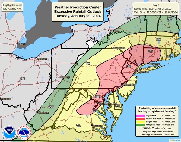
The Flood Watch will be in effect from 1 p.m. Tuesday afternoon through 7 a.m. on Wednesday. A period of moderate to heavy rain is expected to impact the area Tuesday afternoon and evening. Rainfall totals of two to three inches are expected with localized amounts of up to four inches possible.
Excessive runoff may result in flooding of rivers, creeks, streams, and other low-lying and flood-prone locations. Creeks and streams may rise out of their banks. Flooding may occur in poor drainage and urban areas. Low-water crossings may be flooded.
The Wind Advisory will be in effect from 3 p.m. on Tuesday to 1 a.m. on Wednesday.
Southeast winds of 20 to 30 mph are expected with gusts of up to 50 to 55 mph. Gusty winds could blow around unsecured objects. Tree limbs could be blown down and a few power outages may result. Motorists should use extra caution when driving, especially if operating a high-profile vehicle. Residents should secure outdoor objects.
Residents should stay tuned to local forecasts throughout the day on Tuesday.
An approaching storm will produce widespread heavy #rain in the Mid-Atlantic on Tue and Wed. The Weather Prediction Center has issued a large area of slight and moderate risk for excessive rainfall. #NYwx #NJwx #PAwx #DEwx #MDwx #WVwx #VAwx #DCwx pic.twitter.com/bnTVkE2fF5
— NWS MARFC (@NWSMARFC) January 8, 2024