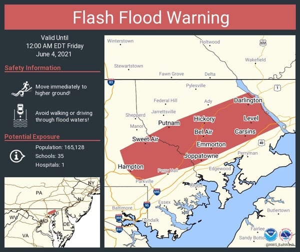
UPDATE 2: A Flood Warning is also in effect until midnight.
UPDATE: The Severe Thunderstorm Warning for the Nottingham/White Marsh/Kingsville area has been extended until 6:15 p.m.
Original story below…
———
NOTTINGHAM, MD—The National Weather Service has issued a Severe Thunderstorm Warning for the Nottingham area.
The warning is in effect until 5:30 p.m. on Thursday and covers Baltimore, Pikesville, Middle River, Cockeysville, Towson, Bel Air South, Parkville, Bel Air North, Carney, Milford Mill, Perry Hall, Lochearn, Rosedale, Rossville, Mays Chapel, Timonium, White Marsh, Fallston, Hampton, and Kingsville.
At 5:15 p.m. EDT, severe thunderstorms were located along a line extending from near Bel Air North to near Fallston to Towson, moving east at 20 mph. Wind gusts of 60 mph and quarter-sized hail have been reported.
Damaging winds will cause some trees and large branches to fall. This could injure those outdoors, as well as damage homes and vehicles. Roadways may become blocked by downed trees. Localized power outages are possible. Unsecured light objects may become projectiles.
Residents should move to an interior room on the lowest floor of a building.
Intense thunderstorm lines can produce brief tornadoes and widespread significant wind damage. Although a tornado is not immediately likely, it is best to move to an interior room on the lowest floor of a building. These storms may cause serious injury and significant property damage.