UPDATE: A Winter Weather Advisory has been issued for the Baltimore area.
Original story below…
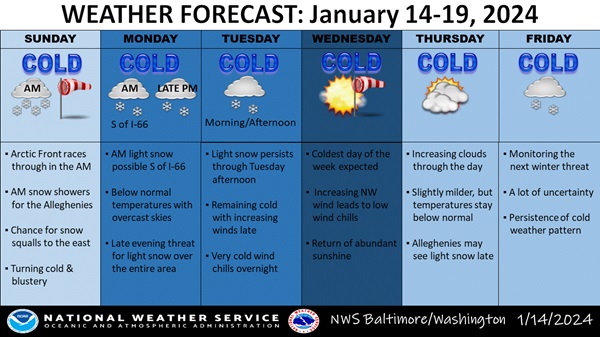
BALTIMORE, MD—Baltimore’s two-year snow drought may finally come to an end this week, according to the National Weather Service. Forecasters say there are several chances for accumulating snow over the next several days.
First, a period of light snow is possible beginning late Sunday night in the Baltimore area. With cold temperatures in place, any accumulating snow may have a significant impact on travel. Light snow is expected to continue through Monday morning.
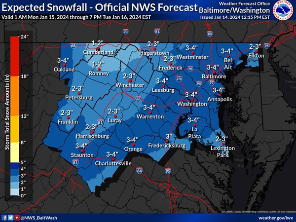
Next, there is an enhanced winter storm threat Monday night into Tuesday morning. Forecasters say 3 – 4 inches of total accumulation are expected before the system exits midday on Tuesday. Significant travel disruptions and closures are possible on Tuesday morning.
The last time 1 inch of more of accumulating snow was measured at BWI was on January 28, 2022.
Dangerously cold wind chills are possible late Tuesday night into early Wednesday morning.
There is also a slight winter storm threat for Friday and Friday night. If the threat materializes, it may cause travel disruptions.
Dangerously cold wind chills are expected Saturday night and into Sunday morning.
Additional information can be found in the National Weather Service graphic below.