
UPDATE: The Winter Storm Watch has been downgraded to a Winter Weather Advisory – detail here.
Original story below…
——
NOTTINGHAM, MD—A wintry mix is expected to arrive in the Baltimore area on Sunday as a major winter storm bears down on the Mid-Atlantic.
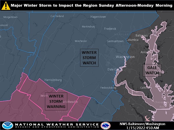
A Winter Storm Watch has been issued in northern Baltimore County for Sunday and into Monday.
The National Weather Service says snow should arrive in the Nottingham area between 1 p.m. and 4 p.m. on Sunday afternoon, then the snow will begin to mix with sleet. Wind gusts of up to 25 mph are expected.
Snow will mix with sleet and freezing rain after 11 p.m., then rain is likely after 11 p.m., then the rain will once again mix with snow after 5 a.m. on Monday. Lows on Sunday night/Monday morning will be around 25 degrees.
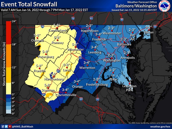
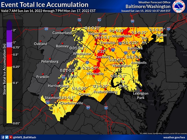
On Monday, wind gusts of around 40 mph are expected. New ice accumulation of 0.1 to 0.25 of an inch is possible. New snow and sleet accumulations of 1 to 3 inches are possible.
A Coastal Flood Watch has also been issued for southern Baltimore County and Baltimore City from Sunday night through Monday morning.
In northern Baltimore County, significant snow and wintry precipitation are expected. Total snow accumulations of 2 to 4 inches are most likely, with up to 6 inches possible. Ice accumulations of around one tenth of an inch are possible. Winds could gust as high as 45 mph.
Snow may fall at 1 to 3 inches per hour late Sunday afternoon and early Sunday evening, resulting in nearly impassable roads.
Motorists should plan on slippery road conditions. The hazardous conditions could impact the Monday morning commute.
Additional information can be found in the graphics below from the National Weather Service.
Snow is in the forecast. Be prepared. Keep an emergency kit in your vehicle with a shovel, ice scraper, gloves, blanket, water, flashlight & cat litter. Fill your gas tank & check your car’s antifreeze, oil & windshield wiper fluid levels. More tips: https://t.co/e7MrEaG8Nf. pic.twitter.com/VsDKj4hCrk
— MD State Highway Adm (@MDSHA) January 15, 2022