UPDATE: Perry Hall, White Marsh, and Carney have been removed from the warning zone, but the storm will still be very close to these areas. Overlea, Fullerton, Rosedale, Rossville, Golden Ring, and areas east of the city remain in the warning zone.
Original story below…
———
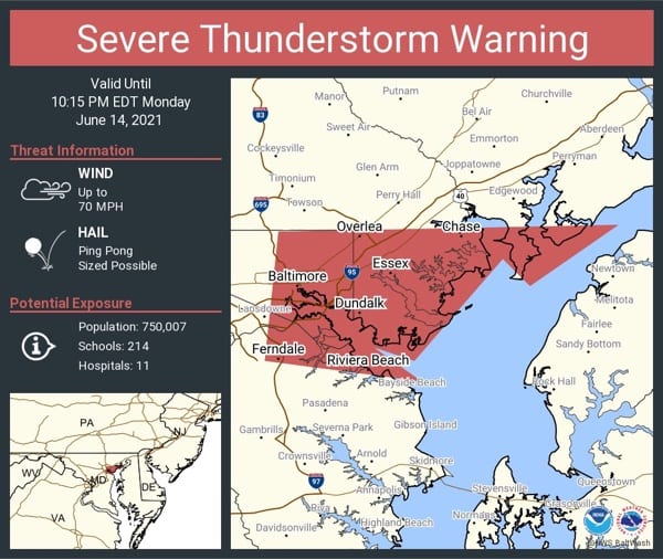
NOTTINGHAM, MD—The National Weather Service has issued a Severe Thunderstorm Warning for the Nottingham area.
The warning will remain in effect until 10:15 p.m.
At 9:30 p.m., severe thunderstorms were located along a line extending from Towson to near Baltimore to Catonsville, moving east at 45 mph.
These storms pack 60 mph wind gusts and quarter size hail.
Damaging winds will cause some trees and large branches to fall. This could injure those outdoors, as well as damage homes and vehicles. Roadways may become blocked by downed trees. Localized power outages are possible. Unsecured light objects may become projectiles.
Locations impacted include Baltimore, Middle River, Riviera Beach, North Point State Park, Sparrows Point, Fort Smallwood State Park, Back River, Millers Island, Glen Burnie, Dundalk, Towson, Essex, Parkville, Carney, Perry Hall, Pasadena, Rosedale, Ferndale, Rossville and Brooklyn Park.
For your protection move to an interior room on the lowest floor of a building.