
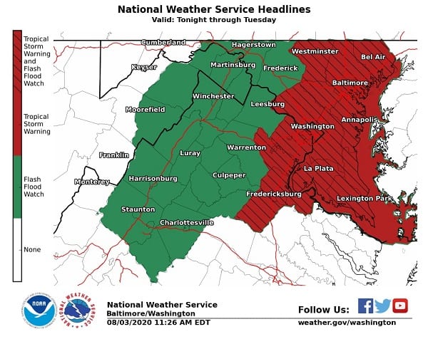
NOTTINGHAM, MD—The National Weather Service on Monday morning issued a Tropical Storm Warning for the Nottingham area.
A Tropical Storm Warning means tropical storm-force winds from Tropical Storm Isaias are expected within the next 36 hours.
The warning covers the entire Baltimore metro area.
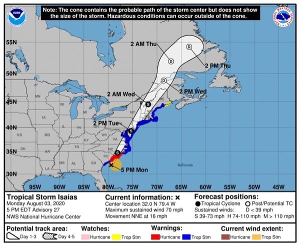
Winds of 35-45 mph are expected with gusts up to 60 mph. The window for tropical storm force winds is Tuesday morning until Tuesday afternoon, according to the National Hurricane Center.
Residents should plan for hazardous winds of equivalent tropical storm force. Remaining efforts to protect property should be completed as soon as possible. Prepare for limited wind damage. Move to safe shelter before the wind becomes hazardous.
READ MORE: MEMA urges preparedness as Tropical Storm Isaias approaches
From the National Weather Service:
– POTENTIAL IMPACTS: Limited – Damage to porches, awnings, carports, sheds, and unanchored mobile homes. Unsecured lightweight objects blown about. – Many large tree limbs broken off. A few trees snapped or uprooted, but with greater numbers in places where trees are shallow rooted. Some fences and roadway signs blown over. – A few roads impassable from debris, particularly within urban or heavily wooded places. Hazardous driving conditions on bridges and other elevated roadways. – Scattered power and communications outages.
* STORM SURGE – LATEST LOCAL FORECAST: Localized storm surge possible – Peak Storm Surge Inundation: The potential for up to 2 feet above ground somewhere within surge prone areas – Window of concern: early Tuesday morning until Tuesday evening
– THREAT TO LIFE AND PROPERTY THAT INCLUDES TYPICAL FORECAST UNCERTAINTY IN TRACK, SIZE AND INTENSITY: Potential for storm surge flooding greater than 1 foot above ground – The storm surge threat has remained nearly steady from the previous assessment. – PLAN: Plan for storm surge flooding greater than 1 foot above ground. – PREPARE: Complete preparations for storm surge flooding, especially in low-lying vulnerable areas, before conditions become unsafe. – ACT: Leave immediately if evacuation orders are given for your area.
– POTENTIAL IMPACTS: Limited – Localized inundation with storm surge flooding mainly along immediate shorelines and in low-lying spots, or in areas farther inland near where higher surge waters move ashore. – Sections of near-shore roads and parking lots become overspread with surge water. Driving conditions dangerous in places where surge water covers the road. – Moderate beach erosion. Heavy surf also breaching dunes, mainly in usually vulnerable locations. Strong rip currents. – Minor to locally moderate damage to marinas, docks, boardwalks, and piers. A few small craft broken away from moorings.
READ MORE: Councilman Marks reminds residents of storm-related resources
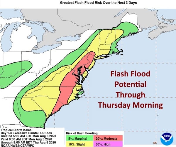
* FLOODING RAIN – LATEST LOCAL FORECAST: Flash Flood Watch is in effect – Peak Rainfall Amounts: Additional 4-8 inches, with locally higher amounts
– THREAT TO LIFE AND PROPERTY THAT INCLUDES TYPICAL FORECAST UNCERTAINTY IN TRACK, SIZE AND INTENSITY: Potential for major flooding rain – The flooding rain threat has remained nearly steady from the previous assessment. – PLAN: Emergency plans should include the potential for major flooding from heavy rain. Evacuations and rescues are likely. – PREPARE: Strongly consider protective actions, especially if you are in an area vulnerable to flooding. – ACT: Heed any flood watches and warnings. Failure to take action will likely result in serious injury or loss of life.
– POTENTIAL IMPACTS: Extensive – Major rainfall flooding may prompt many evacuations and rescues. – Rivers and tributaries may rapidly overflow their banks in multiple places. Small streams, creeks, canals, arroyos, and ditches may become dangerous rivers. In mountain areas, destructive runoff may run quickly down valleys while increasing susceptibility to rockslides and mudslides. Flood control systems and barriers may become stressed. – Flood waters can enter many structures within multiple communities, some structures becoming uninhabitable or washed away. Many places where flood waters may cover escape routes. Streets and parking lots become rivers of moving water with underpasses submerged. Driving conditions become dangerous. Many road and bridge closures with some weakened or washed out.
Hurricane season is underway, & disasters won’t wait for the #COVID19 pandemic. All Marylanders should know whether they live, work, or travel to an evacuation zone before an emergency occurs.
Visit https://t.co/Xm1lVQVvKQ for more information.
Do You #KnowYourZone? pic.twitter.com/gkOyQBZQxb
— Maryland Emergency Management Agency (MDMEMA) (@MDMEMA) July 31, 2020