
UPDATE: Forecasters have increased projected snowfall totals for the Nottingham area.
Original story below…
———
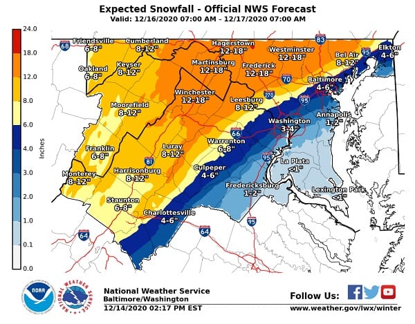
NOTTINGHAM, MD—The National Weather Service has released a snowfall forecast map for the Baltimore area for Wednesday’s winter storm.
The forecast ranges from 4-6″ of snow in southern Baltimore County to 12-18″ of snow in northern Baltimore County.
Nottingham and the surrounding communities look to be squarely in the 6-8″ range, according to the NWS map.
“As you can see, there is a tight gradient of snowfall accumulations along the urban corridor of Baltimore/Washington,” the National Weather Service said on Monday evening. “Areas east of (Baltimore) will see mainly a cold rain, whereas 30 miles to the west could see over 12″ of snow.”
It’s important to bear in mind that the storm track is not yet certain. For the Nottingham area, a slight shift in the track could result in a dramatic increase or decrease in snowfall amount.
A Winter Storm Watch was issued for the area on Monday morning, which will likely be upgraded to a Winter Storm Warning over the next 24 hours.
The latest update on the expected nor’easter Wednesday-Thursday. For many areas this will be the first significant snowfall of the season. If you must travel, please exercise extra caution, and review your winter driving safety procedures. pic.twitter.com/mnRJZALKYf
— NWS Eastern Region (@NWSEastern) December 14, 2020