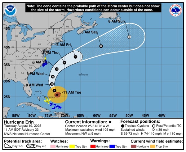
OCEAN CITY, MD—As Hurricane Erin, a powerful Category 4 storm, churns through the Atlantic, Ocean City, Maryland, is preparing for significant coastal impacts, including dangerous rip currents, high waves, potential beach erosion, and coastal flooding, despite the storm’s projected path remaining offshore.
The National Hurricane Center (NHC) has issued Tropical Storm and Storm Surge Watches for parts of the mid-Atlantic, signaling a potentially turbulent week for this popular beach destination.
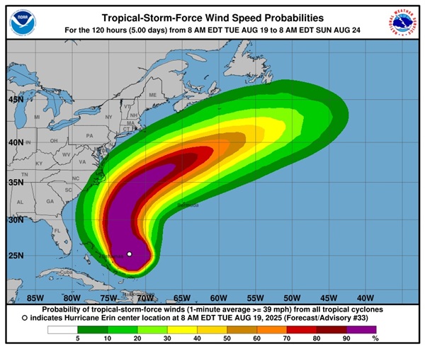
Erin, which briefly reached Category 5 status over the weekend with 160-mph winds, was located approximately 700 miles south-southeast of Hatteras, North Carolina, as of Tuesday morning, moving northwest with sustained winds of 115 mph. While the storm is not expected to make landfall, its massive size is generating large swells that will batter the East Coast, with Ocean City facing hazardous conditions through at least Friday.
The Ocean City Beach Patrol has warned of life-threatening rip currents and rough surf, with wave heights expected to reach 5 to 8 feet by midweek, potentially climbing higher during high tide cycles.
“The ocean is becoming increasingly dangerous,” said Beach Patrol Captain Butch Arbin. “Even on sunny days, rip currents can pull swimmers out to sea faster than they can react. We’re urging everyone to stay out of the water and heed lifeguard warnings.”
Swimming restrictions are in place, and some beach areas may face closures if conditions worsen.
The NHC has issued a Tropical Storm Watch from north of Duck, North Carolina, to Cape Charles Light, Virginia, including parts of the Maryland coast, indicating that tropical storm-force winds of 39 to 73 mph are possible within the next 48 hours. A Storm Surge Watch is also in effect for areas south of Ocean City, particularly the Outer Banks, where storm surge could reach 2 to 4 feet, potentially flooding low-lying areas and inundating roads like North Carolina’s Highway 12. While Ocean City is not under a direct Storm Surge Warning, higher-than-normal tides, amplified by a recent full moon, could lead to minor coastal flooding during high tides on Wednesday and Thursday.
Beach erosion is a major concern for Ocean City, which has faced recurring issues from past storms like Hurricane Ian in 2022, when sand was swept onto the boardwalk. The National Weather Service (NWS) in Wakefield, Virginia, warns that Erin’s swells could erode protective dunes, threatening beachfront properties and infrastructure. Ocean City’s Emergency Management team is coordinating with the NWS to monitor conditions and assess whether measures like reinforcing dunes or restricting beach access will be necessary.
“We’re preparing for the worst while hoping for the best,” said Ocean City Emergency Management Director Joe Theobald. “Our priority is keeping residents and visitors safe. We’re closely watching the storm’s track and are ready to act if conditions deteriorate.” The town has not issued evacuation orders, but officials are urging visitors and residents to stay informed through local sources and the NHC website.
Farther south, North Carolina’s Outer Banks are under Tropical Storm and Storm Surge Warnings, with mandatory evacuations ordered for Hatteras and Ocracoke islands. Dare County officials reported heavy traffic at Ocracoke’s ferry dock as tourists and residents evacuated ahead of expected coastal flooding and waves up to 20 feet. The NWS in Morehead City, North Carolina, warned that “large dangerous waves will likely inundate and destroy protective dune structures,” posing a significant threat to life and property.
Erin’s impacts are already being felt across the region. On Monday, lifeguards in Wrightsville Beach, North Carolina, conducted 50 rip current rescues, while New Hanover County reported 75 rescues along its southern coast. In New Jersey, beaches like Wildwood and Island Beach State Park have prohibited swimming due to hazardous conditions, with waves expected to reach 12 feet by Thursday.
The storm’s effects extend beyond the U.S. Erin’s outer bands lashed Puerto Rico and the Virgin Islands over the weekend, causing widespread power outages and flooding, with over 80,000 customers in Puerto Rico without electricity on Monday. Tropical storm warnings remain in effect for the Turks and Caicos Islands and the southeastern Bahamas, where up to 6 inches of rain and gusty winds are expected through Tuesday.
he NHC is also monitoring two additional tropical waves in the Atlantic that could develop into storms in the coming week, signaling an active hurricane season as it approaches its peak in September.
In Ocean City, local businesses along the boardwalk are taking precautions, securing outdoor furniture and preparing for potential disruptions.
“We’re used to storms, but this one feels different with the waves they’re talking about,” said Lisa Carter, owner of a beachfront café. “We’re hoping it stays offshore, but we’re ready to batten down if needed.”The NHC and local officials urge residents and visitors to monitor updates closely, avoid swimming, and follow lifeguard instructions. “It’s just not going to be a safe environment to be in the ocean this week,” said NHC Director Mike Brennan. For real-time updates, Ocean City residents can visit https://www.hurricanes.gov or follow local alerts.
Maryland State Highway Administration prepares for Hurricane Erin
The Maryland State Highway Administration is preparing for potential impacts from Hurricane Erin, which is not expected to make a direct hit on the state but could cause roadway flooding in some areas.
Crews are clearing drainage inlets and ditches, checking generators and getting high-water signs and chainsaws ready for deployment, the agency announced in a press release Tuesday.
While a direct impact from the storm is not expected, the administration warns of possible roadway flooding due to storm surge during high tides in parts of the lower Eastern Shore and Southern Maryland.
Officials are reminding motorists to heed the “Turn Around, Don’t Drown” safety message. According to the agency, most flood-related deaths occur in vehicles. As little as 6 inches of rapidly moving water can knock a person off their feet, while 2 feet can float a bus.
Motorists should also be aware of other hazards, including:
- Downed power and transmission lines that may still be live.
- Fallen trees, limbs and other debris in the roadway.
- Areas where water is running across the road due to flooding.
The State Highway Administration also advised drivers that if they encounter a traffic signal that is without power or malfunctioning, they should treat the intersection as a four-way stop.
For the latest real-time traffic information on the state highway system, drivers can visit the Coordinated Highways Action Response Team (CHART) website at https://www.chart.maryland.gov. Issues on state-maintained roads can be reported to the Statewide Operations Center at 1-800-543-2515.