BALTIMORE, MD—Hurricane Erin, the first hurricane of the 2025 Atlantic season, is gaining strength as it churns across the Atlantic Ocean, with forecasters warning of dangerous surf, rip currents, and potential coastal flooding along the U.S. East Coast, particularly in the Mid-Atlantic states, as early as next week.
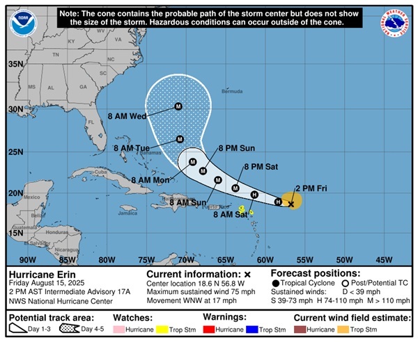
As of 11 a.m. ET Friday, Aug. 15, the National Hurricane Center (NHC) reported that Erin had strengthened into a Category 1 hurricane with maximum sustained winds of 75 mph, located approximately 460 miles east of the northern Leeward Islands. The storm is moving west-northwest at 18 mph and is expected to continue on this trajectory through the weekend, potentially passing near or just north of the northern Leeward Islands, including Anguilla, Barbuda, St. Martin, and St. Barthelemy, where tropical storm watches are in effect.
Forecasters predict “steady to rapid strengthening” over the next few days, with Erin likely to become a major hurricane—Category 3 or higher with winds exceeding 111 mph—by Sunday morning, Aug. 17. Some models suggest Erin could reach Category 4 status with winds up to 130 mph, fueled by warm ocean waters and low wind shear.
While the storm’s exact path remains uncertain, most reliable computer models indicate Hurricane Erin will curve northward, likely remaining hundreds of miles offshore of the U.S. East Coast. This trajectory would spare the Mid-Atlantic states—Delaware, Maryland, Virginia, and North Carolina—from a direct hit. However, the NHC and meteorologists emphasize that even an offshore hurricane can produce significant impacts.
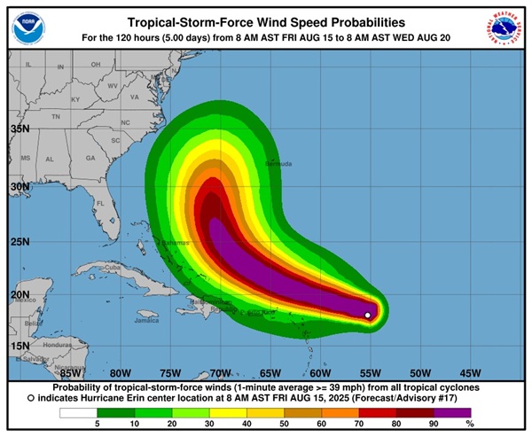
“Beaches along the entire East Coast, from Florida to New England, will likely experience rough surf and dangerous rip currents as Erin tracks north,” said Alex DaSilva, AccuWeather’s lead hurricane expert. “Protruding coastal areas like North Carolina’s Outer Banks, Long Island, and Cape Cod face a higher risk of tropical storm conditions.”
In the Mid-Atlantic, the primary concerns are dangerous surf, beach erosion, and coastal flooding. Swells from Hurricane Erin are expected to reach the region by early next week, generating breakers of 5-10 feet along most coastlines, with 10-15 feet possible in areas like the Outer Banks. Storm surge could inundate low-lying roads, including portions of NC 12, potentially disrupting access to coastal communities.
“There’s still uncertainty about Erin’s impacts on the U.S. East Coast,” said NHC forecasters in a Friday advisory. “Residents in the Mid-Atlantic should monitor updates closely and ensure preparedness plans are in place as we approach the peak of hurricane season.”
The Mid-Atlantic states are no strangers to hurricane-related impacts, even from storms that remain offshore. In Delaware, no rip current warnings were in effect as of Friday, but the NHC noted an increasing risk of dangerous surf by next week. Virginia and Maryland coastal areas could see similar conditions, with potential for minor coastal flooding in low-lying areas.
Hurricane Erin’s projected path will be influenced by the Bermuda High, a semi-permanent ridge of high pressure over the Atlantic. A weaker high could steer Erin farther offshore, while a stronger high might bring it closer to the coast. Current forecasts favor an offshore track, with a less than 10% chance of U.S. landfall based on historical storm tracks and model guidance.
Beyond the Mid-Atlantic, Erin is expected to bring heavy rainfall of 2-4 inches, with isolated areas up to 6 inches, to the northern Leeward Islands, the U.S. and British Virgin Islands, and Puerto Rico starting late Friday. This could lead to flash flooding and mudslides in those regions. Bermuda may also face significant impacts, with wave heights of 15-25 feet and wind gusts up to 100 mph possible, depending on Erin’s proximity.
The 2025 Atlantic hurricane season, which runs through Nov. 30, is forecast to be above normal, with 13-18 named storms, five to nine hurricanes, and two to five major hurricanes, according to the National Oceanic and Atmospheric Administration. Erin is the fifth named storm of the season, following Tropical Storm Chantal, which caused deadly flooding in North Carolina in July.
Meteorologists urge residents along the East Coast to stay vigilant. “Be aware of rip current warning signs and only swim in areas with lifeguards on duty,” DaSilva advised.
The NHC will continue to provide updates as Erin’s path and intensity become clearer. For now, coastal communities are bracing for potentially hazardous conditions, with officials encouraging residents to review hurricane preparedness plans and stock up on supplies.