BALTIMORE, MD—Tropical Storm Erin, churning across the central Atlantic, is on track to become the 2025 Atlantic hurricane season’s first major hurricane by this weekend, with forecasters urging residents along the U.S. East Coast, particularly in the Mid-Atlantic states, to stay vigilant as the storm’s path remains uncertain.
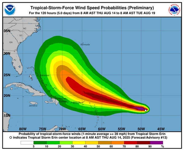
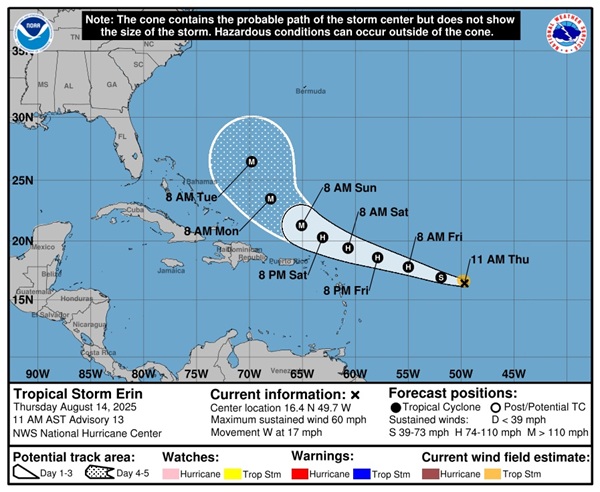
As of 5 a.m. EDT Thursday, August 14, 2025, the National Hurricane Center (NHC) reported Tropical Storm Erin’s center was located approximately 990 miles east of the northern Leeward Islands, moving west at 17 mph with maximum sustained winds of 50 mph. The NHC projects Tropical Storm Erin will intensify into a Category 1 hurricane by Friday and could reach Category 3 status, with winds exceeding 111 mph, by early Sunday.
“Erin is expected to move over warmer waters with low wind shear, creating favorable conditions for rapid intensification,” said NHC hurricane specialist Larry Kelly. The storm is forecast to shift west-northwest by Thursday night, potentially passing near or just north of the northern Leeward Islands, Virgin Islands, and Puerto Rico over the weekend.
While most computer models suggest Tropical Storm Erin will curve northward, steering clear of a direct U.S. landfall, recent shifts in forecast tracks have raised concerns for the East Coast. The European model has occasionally indicated a closer approach, potentially brushing the Outer Banks of North Carolina or areas as far north as Bermuda. AccuWeather Lead Hurricane Expert Alex DaSilva noted a slight southward trend in some models, increasing the chance of U.S. impacts, though he emphasized the most likely path remains between the Outer Banks and Bermuda.
For the Mid-Atlantic states, including Virginia, Maryland, Delaware, and New Jersey, the primary concern is the potential for dangerous surf and rip currents starting this weekend and extending into early next week.
“Even if Erin remains offshore, swells generated by the storm will create life-threatening conditions along East Coast beaches,” said AccuWeather senior meteorologist Chad Merrill. More than 50 rip current-related deaths have been reported across U.S. beaches this year, and officials are urging beachgoers to exercise caution.
The NHC has not issued any coastal watches or warnings for the U.S. mainland, but forecasters stress that the storm’s impacts could extend well beyond its center.
“The forecast cone has an average error of 150 to 215 miles at days four and five,” the NHC said in a statement, underscoring the uncertainty in Erin’s long-term path. A stronger Bermuda High could push the storm closer to the Carolinas or Mid-Atlantic, while a weaker high or an approaching cold front might force an earlier northward turn.
In the Mid-Atlantic, emergency management teams are preparing for possible indirect impacts. In Virginia, officials are monitoring for potential coastal flooding, while Delaware and New Jersey beach communities are bracing for hazardous surf conditions.
“It’s too early to pinpoint exact impacts, but now is the time to ensure preparedness plans are in place,” the NHC advised.
Erin’s potential effects are not limited to the U.S. The northern Leeward Islands, Virgin Islands, and Puerto Rico could see 1 to 2 inches of rain and rough seas by the weekend. The Bahamas and Bermuda are also advised to monitor the storm closely.
The 2025 Atlantic hurricane season, which runs from June 1 to November 30, is expected to be above-normal, with NOAA forecasting 13 to 18 named storms, including 6 to 10 hurricanes and 3 to 5 major hurricanes. Erin, the fifth named storm of the season, formed earlier than the historical average for the first hurricane, typically seen around August 11.
Residents along the East Coast are encouraged to stay informed through local weather updates and to prepare for potential disruptions, including securing disaster supplies and reviewing evacuation plans. “This is the climatological peak of the hurricane season,” the NHC said. “Now is the time to act before conditions worsen.”
For the latest updates, visit the National Hurricane Center at https://www.nhc.noaa.gov.
Photos via the National Hurricane Center
